Location Report

Contents
Process:
•Verifying the location of the objects on the track topology.
Requirements:
Description:
For all objects in the drawing, their location at the topological edge is verified. The object is located, if there are values for the attributes 'Edge', 'Distance TOP' and 'Lateral distance' of an object.
Procedure:
1.Launch report for localization.
Command Line: VERORTE_REPORT
Ribbon: ProSig EPU -> Tools -> Services -> Location Report
oIf an object is located at the topological edge, the base point of the object is marked with a circle (layer PRS-TEMP).
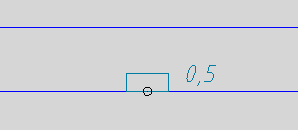
Illus.: Display of the location of a track magnet
oIf the base point of the object is not located directly on the topological edge, a line (layer PRS-TEMP) is drawn from the base point to the location point on the edge.
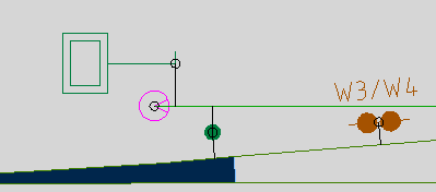
Illus.: Display of the location of signals, fouling point markers and axle counter points
oFor objects that are not located, zoom functions are created and a report is generated. The objects in the project drawing can be zoomed by entering the zoom number in the command line. If there are objects with a station on the topological edge, they are displayed together with a corresponding symbol (locator, layer PRS-NICHT-VERORTET) in the drawing. Afterwards, these objects can be located using the function Locate Individual Objects.
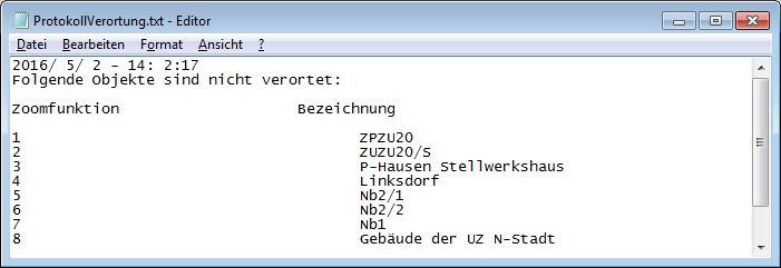
Illus.: Protocol for localization with zoom functions and associated objects
oIf all objects are located, the following message is displayed in the command line: 'All objects are correctly positioned on the topology.'